
From the Toysit archive
United States Map Puzzle
Revisit the Milton Bradley United States Map Puzzle through state outlines, neighbors and map symbols, then plan a route using a current map.
The play at a glance
Build the map, then ask what it shows
A map puzzle offers two kinds of clues: the edges that join and the geography printed on them. Toysit’s original account describes a Milton Bradley eighty-four-piece United States puzzle, with many pieces following state outlines. Its enduring invitation is to look beyond a familiar name and notice where a state sits in relation to others.
Use neighbors as clues
Choose a familiar state and find the states around it. Look at shared borders, the coastline and the position of labels. These clues can help explain why a piece belongs in a particular area without requiring every capital to be memorized first.
A jigsaw join and a geographic border are not necessarily the same thing. The old review describes exceptions for small states, so do not assume one piece always equals one state. Use the printed lines and names as well as the cut.
Read the map’s conventions
A star, a dot and a colored area can communicate different information. Look for a key or legend before deciding what a symbol means. If no key is available, compare with a clearly labeled reference rather than guessing.
Alaska and Hawaii are often placed in separate inset areas to fit a national map on a page. Their placement below the main map does not make them neighbors of the states immediately above them. Insets may also use a different scale; use a wider map to locate them geographically.
Keep an old map and a current reference side by side
The original account mentions cities, products and industries. Treat those details as part of the map’s historical presentation. Check a current atlas for present-day information rather than assuming every symbol or label is still representative.
Using a reference is a way to investigate the puzzle, not a failure to solve it unaided. Ask what the reference clarifies and what the puzzle makes easier to notice.
Make a three-state neighbor route
On a current state map, choose a starting state in the contiguous United States. Find a state that shares a stretch of border with it, then a third that shares a stretch with the second. Write the three names as a route. For this activity, touching only at a corner does not count.
Trace the route with a finger and explain each connection. Try another route from the same starting point. This independent Toysit geography activity needs no historical puzzle and does not represent a driving itinerary.
The historical record
Original Toysit coverage
The full original review and later map-puzzle essay remain below. Their product specifications, price, age-safety statements, curriculum expectations, learning-style language and promises about memory are historical claims, not current guidance or tested outcomes.
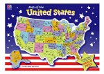
Map of the United States 84-piece Jigsaw Puzzle.
This 84-piece jigsaw puzzle assembles into the 48 contiguous United States, plus Alaska and Hawaii. The pieces are large enough to be safe for curious little ones and make for a fun and truly hands-on lesson in geography. The mapping is detailed enough to highlight major cities and towns, as well as rivers and some topography. To test your smarts, try constructing it without the benefit of a map. Along about fourth or fifth grade, students in the U.S. are expected to memorize all of the states, their locations, and their capital cities. If you can manage to get a jump-start on this very necessary chunk of information, so much the better for your child: it will be easier for them to learn later, and there's a much greater chance of permanent retention. This is where puzzles and card games can be really helpful, especially if they're well designed.
Milton Bradley's United States puzzle has much to recommend it: it's inexpensive, for one thing, the pieces are large and easy to manage (average size is about 2 by 2 inches), and it contains an awful lot of information. Latitude and longitude lines, major products and industries, and of course major cities and capitals are all represented in simple graphics. Except for a few of the tiny Atlantic seaboard states, puzzle pieces are actually cut along state borders--giving kids a handle on their individual geographical shape. A border of interlocking puzzle pieces keeps them in their proper places. The second grader who enjoys puzzles will learn a great deal just by putting it together a few times; older children--especially hands-on and visual learners--will have a lot more fun acquiring the facts with a puzzle than by desperately (and temporarily) memorizing them the night before a test.
Map puzzles serve as an interactive and engaging way to introduce children to geography. As they piece together regions, countries, or states, kids inherently learn about borders, landmarks, and spatial relations. Unlike passive learning from a book or screen, the tactile nature of a puzzle helps to reinforce memory and retention. The activity also fosters problem-solving skills as children figure out where each piece fits in relation to the others. Additionally, map puzzles often come with labels for cities, rivers, mountains, and other geographical features, thereby enriching vocabulary and general knowledge. They offer a hands-on experience that not only teaches children about the world they live in but also promotes cognitive and motor skills, making them an excellent educational tool.
Sources and editorial notes
This profile uses Toysit’s original Milton Bradley description and retained image. No exact manufacturer guide or legible edition record was matched, so piece count, dimensions and state-shaped cuts remain attributed to the original review. The image cannot establish the currency of labels, industry symbols or statistics. This page is distinct from Toysit’s separate USA Map Puzzle. No physical puzzle or learning outcome was tested.
Images and descriptions are retained as historical material. How Toysit covers toys.
Created for Toysit by Tabbloza — the artwork in our header.